Un mapa viejo
 Here's a serendipitous event: a Corpus Christi city library director went to Spain and discovered there a map of Corpus Christi from 1766! It's actually not the only map of the region from that time; there's another. What makes this one so interesting is it shows Karankawa and Malaquite Indian settlements and the locations of two wrecked English ships. (Judging by the number of cannon on the drawing, they're probably military ships and not likely to be laden with dubloons or anything!)
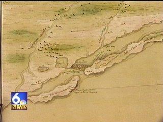
Sometime around 1747 Don Joaquín Orobio y Basterra found the bay and named it San Miguel Arcángel. In 1766, rumors of English ships landing on the coast led Don Diego Ortiz Parrilla to take an expedition to the Gulf. He did not find any Engilsh ships but he did remap the area and renamed the bay Corpus Christi. These maps are a glimpse back into the earliest history of Corpus Christi.*
*That is, of course, strictly from a Eurocentric perspective. The Karankawas were here first, etc. Unfortunately for us, they leave behind little more than oyster mounds and we don't know their history.

1 Comments:
That's really interesting. I had no idea Corpus had been around that long.
Nora
Post a Comment
<< Home